
Bombardment Pass
The Chugach Drum Solo
Published 10-9-2022 | Last updated 10-9-2022
61.231, -149.166
[Unofficial name, no GNIS Entry]
The deep piles of loose rock covering the slopes and valleys of mountain ranges like the Chugach have some interesting and poetic names: talus, scree, colluvium. It's the opposite of onomatopoeia; the actual sounds those lumps and shards of stone make as they clatter down are staccato, harsh, and nothing like the beautiful names we reward them with when they come to a collective stop.
How prone a mountain range is to rockfall is determined by the strength of the rocks it is made of. Strong rocks such as granite form tall peaks and majestic cliffs like the Alaska Range. The Chugach is notoriously brittle. One of its major geologic components is a “mélange,”[1] which is a polite term geologists use “to indicate a vast group of 'chaotic rock'.”[2] It breaks easily and often, and so chunks have been whizzing downhill ever since the glaciers which the peaks were once encased in began retreating 12,000 years ago.
A practical effect of this is that backcountry travelers learn to place a high premium on helmets and careful movement. Many Chugach mountaineers have stories in which, with no warning, rocks hurtled past them at terminal velocity and precisely at face level. Others have stories of barely resting a hand on what seemed like a solid surface, followed by a dreadful feeling as a refrigerator-sized block began to pivot out of balance.
But from the safety which comes with distance, the more noticeable effect is the soundscape. Day in and day out for millennia, gravity has been playing a drum solo of pops, cracks, and rumbles as the Chugach mountains shed.
The music is loud near a particular pass which links the modern end of Eagle River Road with the headwaters of Peters Creek through a series of hanging valleys. The pass lies below the steep northern cliffs of Koruhusk Peak, the westernmost mountain in the Chugach standing over 7000 feet. On the Eagle River side, the Ram Valley Glacier is covered by a blanket of rocks which have tumbled down over the centuries and may actually be protecting it from melting faster.[3] No ice is visible on the Peters Creek side, but there's a chance a scrap of glacier remains under the accumulated scree, the way it was mapped in 1960.[4] No name for the pass is remembered in Dena’ina, but routes at similar elevation and distances from the coast were known to be used for travel from the South Fork to the main branch of Eagle River,[5] and from Peters Creek to Eklutna Lake.[6]
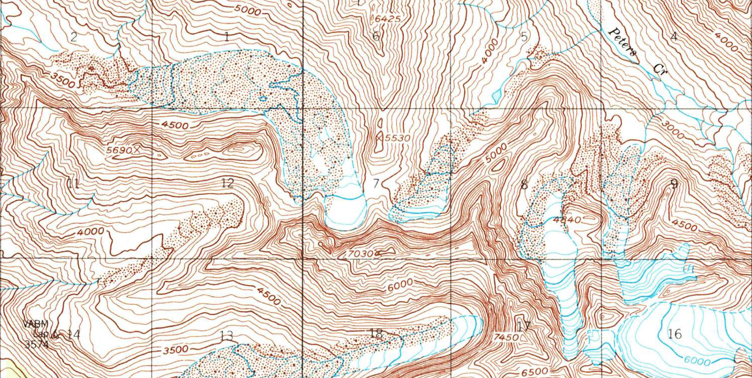
Excerpt of the Anchorage A-6 Quadrangle, 1:63360, 1960,[4] showing Korohusk Peak (7030 feet), the Ram Valley Glacier to the west, and Peters Creek to the east. Bombardment Pass is located in the center of the image, under the printed '7' which labels the Section grid. The stippling in the valleys indicates the scree fields produced by constant bombardment.
In July 1966, climbers Dave Meyers and Vin Hoeman spent a night camped at this saddle, and named it ‘Bombardment Pass’ for “the almost constant rockfall from neighboring 'Korohusk'.”[7] With the prudence of good mountaineers, they made sure to place their camp so the debris only made a metaphorical impression. The climbers’ goal was the first recorded ascent of ‘Mount Rumble,’ a beautiful behemoth between the forks of upper Peters Creek which had been named from afar slightly earlier for similar reasons, and they succeeded at that too.
The proposed name was officially rejected by the State Board of Geographic Names in 1967 because the “character was not peculiar to this pass,”[8] to which Vin Hoeman responded “So what!”[9] The name is still unofficial but firmly in local use, and the Chugach and many who love it still march to the beat of their own drummer.
Sources
[6] Ibid., 325. (Htestighitun Tustes)
[7] Hoeman, J. Vin. “Mount Rumble 7530” The Scree, Mountaineering Club of Alaska, September 1966.
[8] Hoeman, J. Vin. “Names Dilemma” The Scree, Mountaineering Club of Alaska, February 1967.
[9] Hoeman, J. Vin. “Names” The Scree, Mountaineering Club of Alaska, October 1967.